Current and Past Research
Active Tectonics, Active Landscapes and Human-Environment Interactions
Teaching
Research Projects
Resources + Opportunities
Toke CV
Active Tectonics of the Central San Andreas Fault
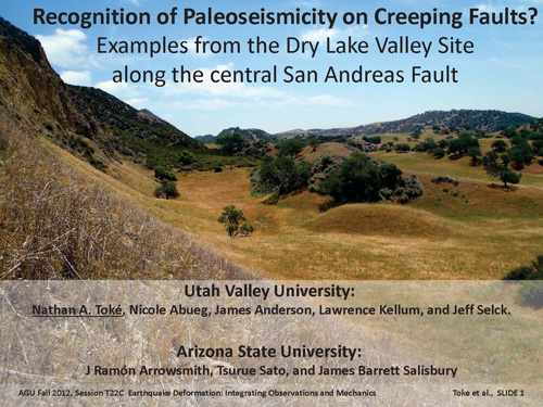
Dry Lake Valley
Central SAF Mapping
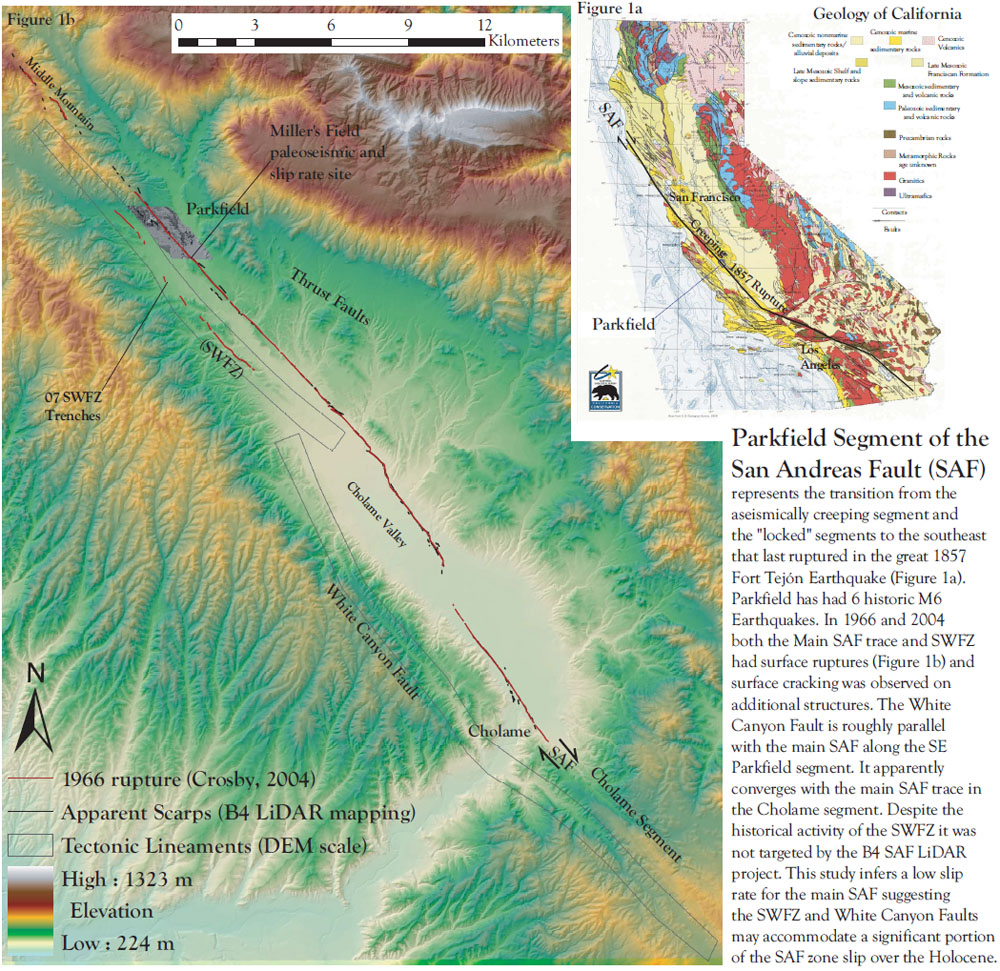
Parkfield Section
Intermountain Seismic Belt: Faulting, Volcanoes, Mass Wasting, and Quaternary Geomorphology
Wasatch Fault Segment Boundary Trenching
Lake Bonneville Terrace Study
Black Rock Desert Faults and Volcanics
Drainage-Damming Landslides of the central Wasatch
Borah Peak Earthquake Rupture
Thousand Lakes Fault and Geologic Mapping
Oquirrh and Topliff Hills Fault System
Genola North and Utah Lake Faults
RockFall Frequency in St. George
Additional Active Tectonics Research
Slip Rate Uncertainties
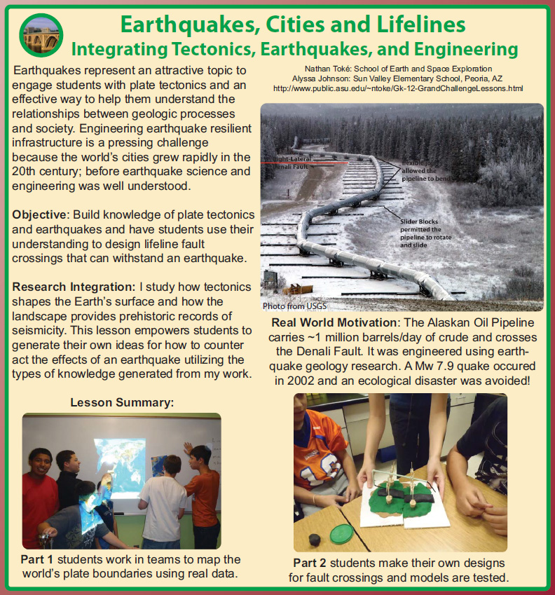
Denali Fault
Geomorphology, Landscape Development and Socio-envrionmental interactions
Land Cover and Land Use Change in Utah Valley
AP Fault Zones, Greenspace and Social Vulnerability
Geomorphic Change in Aridland Streams
Urban Sedimentation in Tempe, AZ
Urban Hydrology of Indian Bend Wash
Education research
Tectonic Geomorphic Indicators Using Google Earth
Interdisciplinary Education Perspectives
K-12 Plate Tectonics and Fault Activies
Peer-Reviewed Papers
Ferrarini et al., 2021 - Frontiers in Earth Science : Editorial: Unveiling Active Faults: Multiscale Perspectives and Alternative Approaches Addressing the Seismic Hazard Challenge
Toke et al., 2021 - Frontiers in Earth Science : The Traverse Ridge Paleoseismic Site and Ruputres Crossing the Boundary Between the Provo and Salt Lake City Segments of the Wasatch Fault Zone – Utah, USA
Scott et al., 2020 - JGR Solid Earth: “Creep along the Central San Andreas Fault Imaged from Surface Fractures, Topographic Differencing, and InSAR Imagery
DuRoss et al., 2019 - Geosphere: Variable normal-fault rupture behavior, northern Lost River fault zone, Idaho, USA.
Carlson et al., 2018 - BSSA : Documentation of Seven Earthquakes over the past ~7000 Yearson the West-Central Denali Fault at the Nenana River.
Toke et al., 2017 - UGA Pub. 46: Inferences about Segmentation from Recent Surface Breaks along the Wasatch Front revealed from Lidar, SfM, and Outcrops from American Fork Canyon to Dimple Dell Regional Park, Utah
Toke et al., 2014 - Earth's Future: Fault zone regulation, seismic hazard, and social vulnerability in Los Angeles, California: Hazard or urban amenity?
Haddad et al., 2012 - Geosphere : Applications of airborne and terrestrial laser scanning to paleoseismology
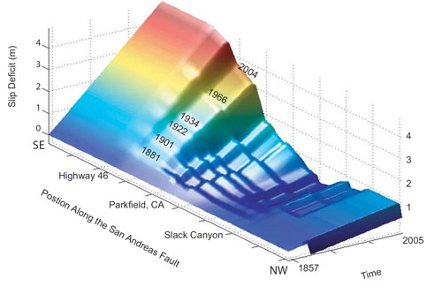
Toke et al., 2011 - Geology : Late Holocene slip rate of the San Andreas Fault and its accommodation by creep and moderate magnitude earthquakes at Parkfield, California
El Ashmaway et al., 2009 - Arizona Hydrology Symposium Proceedings: Geologic Investigations of Urban Sedimentation in Tempe, AZ Using Retention Structures
Toke et al., 2006 - BSSA: Paleoseismic and Postseismic Observations of Surface Slip along the Parkfield Segment of the San Andreas Fault
Toke and Arrowsmith, 2006 - BSSA : Reassessment of a Slip Budget along the Parkfield Segment of the San Andreas Fault
Rymer et al., 2006 - BSSA : Surface Fault Slip Associated with the 2004 Parkfield, California, Earthquake
Dissertation and Thesis Papers
Toke, 2011 - ASU Ph.D. Dissertation: Earthquake Geology, Hazard, Urban Form and Social Vulnerability along the San Andreas Fault
Toke, 2005 - ASU M.S. Thesis: Paleoseismology, Slip Budget, and Fault Behavior along the Parkfield Segment of the San Andreas Fault
Toke, 2003 - UVM Undergraduate Thesis : Compacted Greenspace and Stormwater Hydrology in Burlington, Vermont
Working within the Active Tectonics Research Group in the School of Earth and Space Exploration at Arizona State University We are engaged with research studying the geologic history of slip along the central San Andreas Fault.
Our UVU group and ASU's Active Tectonics group are collaborating on a SCEC research project studying the Earthquake Geology and Geomorphology of the Creeping Section of the San Andreas Fault.
Here are products eminating from this research so far:
2012 Proposal (funded): Paleoseismic investigation along the inferred northernmost extent of the 1857 rupture: Do large San Andreas Fault Ruptures extend into the Creeping Section?
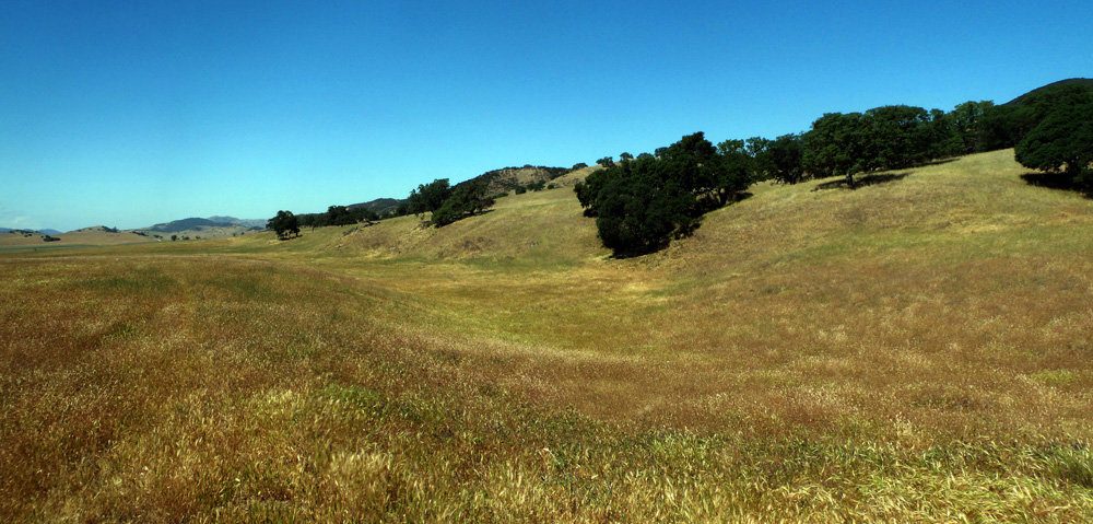
2012 SCEC Poster:
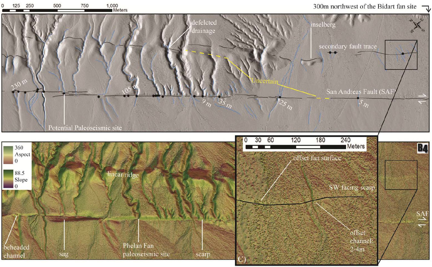
Preliminary Results: The 2012 Dry Lake Paleoseismic Site on the Central Creeping Section of the San Andreas Fault
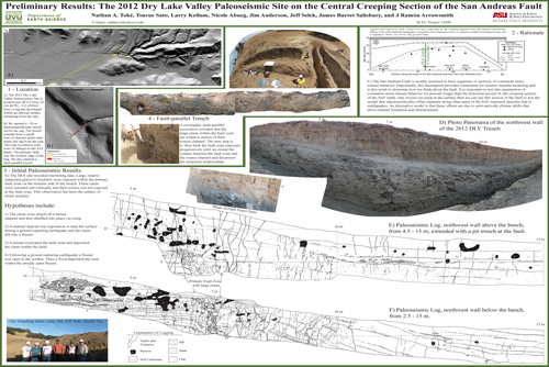
2012 Fall AGU Meeting Presentation Abstract: Recognition of Paleoseismicity on Creeping Faults? Examples from the Dry Lake Valley Site along the central San Andreas Fault
PDF of slides:
2012 SCEC Annual Report: Final Technical Report
2013 Proposal (funded): Examing the cause of significant ground deformation between 780 and 1031 A.D. at the Dry Lake Valley Paleoseismic Site: Do large earthquakes rupture the creeping section of the San Andreas Fault?
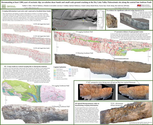
2013 SCEC Poster:
Documenting at least 1300 years of aseismic slip: en-echelon shear bands and small-scale ground cracking at the Dry Lake Valley Paleoseismic site along the Central San Andreas Fault
2015 BRPSHSIII Poster by Mike Bunds:
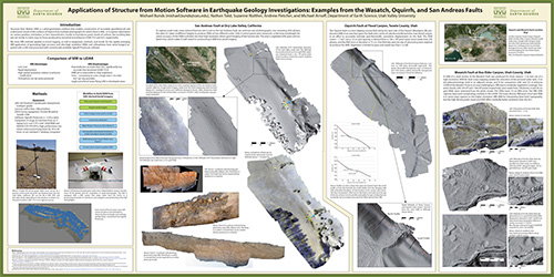
Applications of Structure from Motion Software in Earthquake Geology Investigations: Examples from the Wasatch Oquirrh, and San Andreas Faults
2013 SCEC Annual Report: Final Technical Report
Check our my dissertation for initial results, here is a preview:
As a part of my graduate research I published four papers related to the geology of the Parkfield section of the San Andreas Fault:
Toke et al., 2011, Late Holocene slip rate of the San Andreas fault and its accomodation by creep and moderate-magnitude earthquakes at Parkfield, California: Geology
Toke and Arrowsmith, 2006, Reassessment of a Slip Budget along the Parkfield Segment of the San Andreas Fault BSSA
Toke et al., 2006, Paleoseismic and Postseismic Observations of Surface Slip along the Parkfield Segment of the San Andreas Fault BSSA
Rymer et al., 2006, Surface Fault Slip Associated with the 2004 Parkfield, California Earthquake BSSA
Much of this work is also presented in my MS Thesis and PhD Dissertation .
Intermountain Seismic Belt: Faulting, Volcanoes, Mass Wasting, and Quaternary Geomorphology
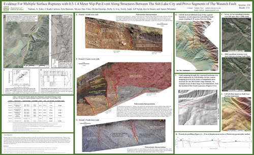
Together with Kade Carlson and members of the 2013 UVU Geology Field Camp we logged three exposures of the Wasatch Fault where it steps across the Traverse Ridge salient between the Salt Lake City and Provo Segments of the Fault.
This is some of this first paleoseismic work to be done at this important part of the Wasatch Fault, we presented our initial results at the 2013 Annual GSA Meeting in Denver:
Evidence for Multiple Surface Ruptures with 0.3-1.5 meter Slip-Per-Event Along Structures between the Salt Lake city and Provo Segments of the Wasatch Fault
Poster:
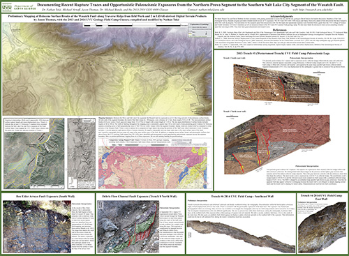
This research has continued on with the 2014 Field Camp, Mike Arnoff, and Jason Thomas and was presented at the Basin and Range Seismic Hazard Summitt III:
BRPSHSIII Webpage
Poster:
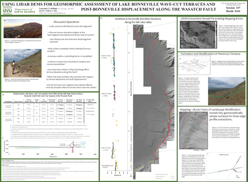
Together with Larry Kellum we have been re-assessing the elevations of the Bonneville highstand terraces across the Salt Lake City segment of the Wasatch Fault.
Larry's research helps decipher the record of slip along the fault segment.Larry presented his work at the 2013 Annual GSA Meeting in Denver:
Using Lidar DEMs for Geomorphic Assessment of Lake Bonneville Wave-cut Terraces and Post-Bonneville Displacement along the Wasatch Fault
Poster:
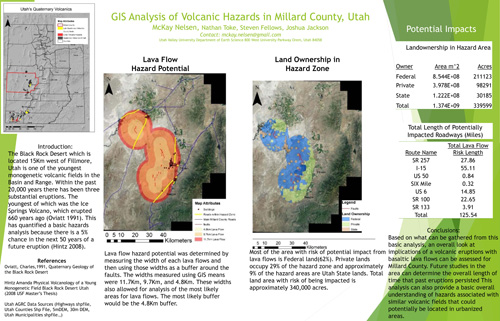
Inspired by McKay Nelsen's interest in volcanology, we've begun to look at faulting and volcanism in the Millard County Volcanic Field which last erupted effusively ~600 years ago!
McKay presented a GIS analysis of potential volcanic hazards from future eruptions at the 2015 RM GSA Meeting in Casper WY:
GIS ANalysis of Volcanic Hazards in Millard County, Utah
Poster:
In collaboration with Steve Nelson and John McBride at BYU we are seeking NEHRP funding to study the recurrence of Earthquakes along the Clear Lake Fault Zone within the Black Rock Desert Volcanic Field
2015 UVU/BYU NEHRP Proposal
Together with Mike Bunds, Nick Butterfield, and Alessandro Zanazzi we are investigating the timing of large Landslides within the central Wasatch range and their impact on drainage basin geomorphology and hydrology. Research is ongoing... More to come...
The research has been funded by iUtah and preliminary results are forthcoming at GSA 2015 in Baltimore, MD.
Collaborating with Michael Bunds, the USGS Earthquake Hazards Team in GOlden, CO and Ed Nissen's Graduate Students at the Colorado School of Mines we are using SfM to map the 1983 Borah Peak rupture. Research is ongoing... More to come...
Initial results will be presented by Mike Bunds at the 2015 Annual GSA meeting in Baltimore, MD.
Together with the 2015 UVU Field Camp I mapped bedrock geology and reconnaisanced the Thousand Lake's Fault for Paleoseismic Analysis. Research is ongoing... More to come...
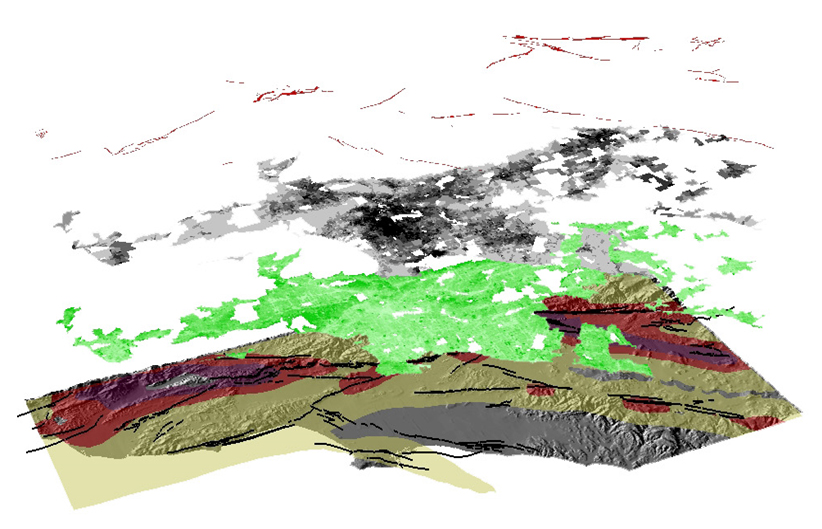
Collaborating with Michael Bunds and students we have been progressively mapping the Oquirrh Fault using SfM. Research is ongoing... More to come...
Kristen Smith is leading an undergraduate paleoseismology project at the West Mountain Site and will be presenting her results at the 2022 GSA meeting in Denver... More to come...
I am looking for students to carry forth this Mapping and Geomorphology project... More to come...
Additional Active Tectonics Research
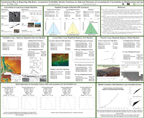
Since first beginning to account for uncertainties in slip rate estimations using Probability Density Functions (PDFs), I have been interested in the geometries of the resulting PDFs when convoluting uncertainties in age and offset.
Using several examples, I show that asymmetry is an expected result in slip rate PDF uncertainty analyses. Please refer to my 2014 SCEC Abstract. and Poster:
Poster:
I participated in paleoseismic field work led by Kade Carlson and Sean Bemis of the University of Kentucky. Initial results will be presented at the 2015 AGU meeting...
Socio-environmental Interaction
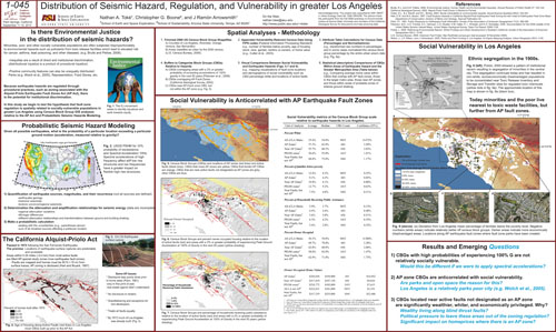
As a part of a graduate seminar on Environmental Justice I developed a GIS-based research project investigating the geographical links between Fault Zone Regulations, Urban Development, and Patterns of Social-Vulnerability in Los Angeles, CA. This work is a major component of my dissertation.
The work has also been presented as a peer reviewed article and in a poster at the Southern California Earthquake Center Annual Meeting.
2014 Earth's Future Paper: Fault zone regulation, seismic hazard, and social vulnerability
in Los Angeles, California: Hazard or urban amenity?
Poster:
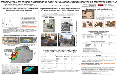
Together with a Civil, Environmental and Sustainable Engineering Undergraduate Student at ASU (Laila El-Ashmawy) we tracked sediment production in the urbanized desert environment in Tempe, AZ.
Laila published her work in several venues:
2009 Arizona Hydrological Society Meeting Paper: Geologic Investigation of Urban Sedimentation Using Retention Basins in Tempe, AZ.
2009 GSA Annual Meeting abstract: Sedimentary Geology of Urban Environments: An Example of Measuring Sediment Production and Composition in Tempe, AZ.
Poster:
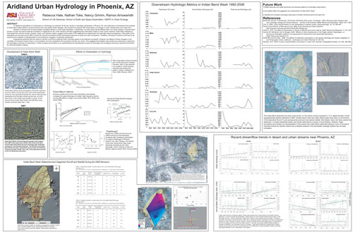
Working with graduate school contemporary Rebecca Hale as a part of our Urban Ecology graduate seminar we spent considerable time analyzing the hydrologic record of Indian Bend Wash to see how urbanization and managment influenced basic hydrologic parameters for this desert stream.
One outlet for this research was the 2008 CAP-LTER Annual Symposium. Rebecca has taken this work a lot further: E.G., Her Dissertation.
Poster:
Also check out my undergraduate thesis on relationships between greenspace compaction and stormwater runoff in Burlington, VT: John Dewey Honors Thesis
Education Outreach and Research
As a part of our Geomorphology class we're having students calcualte indicies of tectonic activity along the Wasat Front using Google Earth. We plan to compare these analyses with state of the art assessments using high resolution DEMs. Check back soon for updates
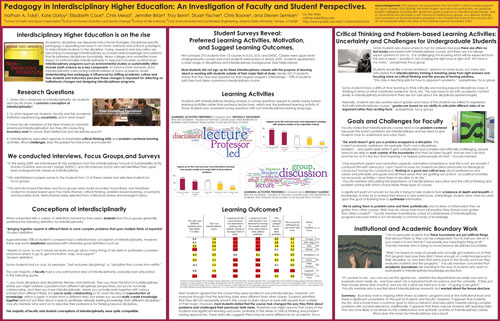
As a part of ASU's IGERT in Urban Ecology program we conducted a workshop course investigating faculty and student perceptions of Interdisciplinary Education at Arizona State University. Several conference presentations eminated from this project.
E.g., Toke et al., 2009 GSA Abstract: Pegagogy in Interdisciplinary Higher Education: An Investigation of Faculty and Student Perspectives.
Poster:
See my teaching page for lesson plans like the ones depicted at the beginning of this section.
Direct questions to:
Nathan A. Toke